Why at last? Well it seems that ever since I met Lesley some **'s years ago, we have travelled and walked the length and breadth of this stunning strip of hills that borders the 3 counties of Worcestershire, Gloucestershire and Herefordshire.
Running roughly from North to South and at places less than 1/2 mile wide x 8 miles long and just under 1400ft at the highest point, however it definitely punches above it's weight when it comes to stunning views and accessible, challenging walking. All the hills are named and we used to try and 'peak' all of them on our annual 'sabbatical' to mark the birthplace of Lesley's father in nearby Malvern, where Lesley can still feel his presence when we pause to soak up the scenery on one of the many 360 degree vistas.
The English composer, Elgar, is synonymous with the region and equally 'famous' are the quantity of springs located all around the hills where locals and visitors take in the refreshing water for not only hydration but it is believed to ![]() have health and medicinal powers. Beware though that due to the flocks of sheep, herds of lovely Belted Galloway and striking 'blonde' Highland cattle that graze areas of the hills, some springs and wells carry a notice that they are currently out of bounds for drinking water.
have health and medicinal powers. Beware though that due to the flocks of sheep, herds of lovely Belted Galloway and striking 'blonde' Highland cattle that graze areas of the hills, some springs and wells carry a notice that they are currently out of bounds for drinking water.
We could have chosen any number of stunning walks for Walking Over The Hill but we wanted to put down on paper our most recent one-day holiday walk taking in the northern end, stretching from near The Malvern Hills Hotel to North Hill and return.....in an almost figure of 8 loop with a couple of peaks on the way.
If you arrive by car, please try and park in the designated area car-parks found all around the hills and not in the residents parking or narrow lanes. Pay the £4.20p* for the whole day as funds go to a good cause, that is, the Malvern Hills Trust. This Trust maintains the hills keeping them looking fabulous whatever time of the year you may visit. We started the loop from the Gardener's Quarry car-park on the west facing side, close to The Kettle Sings cafe.(a start and/or finish gem) Use WR13 6DN for both cafe and carpark. An alternative if you choose public transport is available with a service from Malvern up to the Wyche Crossing where you can start and finish this walk.
Walk north through the carpark and take a right fork on a wide track leading quite sharply upwards until it joins the main path that leads again north towards the Wyche crossing. The keener walker can start by taking in the peaks which leaves a less challenging choice of taking the first of the lower side paths, equally pretty, but without the huffy-puffy bits...... just yet! Views all around are magnificent unless you are unfortunate, like us on a couple of occasions, to be in a grey-low-cloud clag-day, so weather forecasts beforehand, as usual, are important!
Join the side path and follow it until its meets with a road that needs to be crossed with great care. Before you do, there are the last toilets just around the corner and a cafe over the road in the eco-centre.....worth a visit if you have time, to get a perspective of the Malvern's from the large maps on the wall and rock samples of the complex geology that make up these ancient hills........oh! and the homemade cake is nice! Walk up passing the cottages on your right and take an immediate path right upwards and over towards the east side of the hill where it ascends besides a quarry until it drops down some steps to a stone mound with directions on the top of it. Although tempting, today we aren't taking the wide metalled path but peeling off to the right and down hill for a short distance before a forked choice. Don't go down besides the wall but take the left fork ascending slightly again before levelling out with views now over the trees to your right. The next section starts with a zig (3) and zag (2) down through the trees passing warning quarry signs and views down to a clear quarry-lake. On a zig, a clear narrow path goes straight on and that's our path today as although you may not find it marked on a map, it is well defined and can be a little challenging as there are plenty of roots and a few rocks to pick your way over. It's well worth the several hundred yards 'off piste' as the path follows roughly the contours of the hill with a few ups and downs before it meets with a more well defined and map-marked footpath. 
Carry straight on and keep following contours, pausing for photo stops and views before winding around the hill, still keeping fairly level and passing an 'everlasting' spring on your left. The path divides again at an uprighted rock. Take the right fork again keeping to the slightly rising path that winds around the contours of the hill before climbing more steeply towards a col where there is an intersection of many paths marked by another circular directional stone. Pause and look up at the large hill behind you where you may just see it capped by the Worcestershire Beacon and usually surrounded by a small gathering of people marking their achievement with a 'selfie' or simply taking in the views. This hill is for later as there is still some walking to do as you make for the broad path circling the hill to the north. This track is called Lady Howard De Walden Drive named after an ennobled resident of West Malvern who despite only living in the vicinity for less than 10 years has this superb circular path named after her, arguably with the best views over Malvern town, Worcester and onwards to the Black Country. Like a lot of the broader tracks surrounding the hills this may be used by walkers and cyclists alike and there is now an excellent leaflet marking all the dual purpose tracks that the Malvern Hills Trust manage. Link here to access a digital copy from the Malvern Hills Trust web-site.
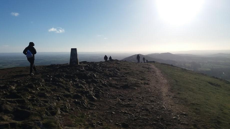
Skirt around North Hill which incidentally is the second highest peak after the Worcestershire Beacon, until you have a view over Malvern Link below with a steep path coming up from your right and cutting across your track. You are around half way on this circular path with a gap between the hills on your left, take this crossing path up steeply until you summit with views towards the Beacon. You could go to the top of North Hill.....just to say you have or carry on the path always bearing slightly right towards Sugar Loaf hill, the third highest. From the top of Sugar Loaf the views west towards Wales are a joy and on a clear day the distinct shape of the Black Mountains and the dramatic edges of the Brecon Beacons are easily visible. The immediate picture below is formed of undulating fields akin to what you would draw if asked to paint the 'typical' English countryside. Churches, farms, small fields of varying colours, trees and cattle grazing make for a 'timeless' scene. Moving on, we now have the beacon in site, still looking quite formidable! Descending back to the stone direction marker there is a clear choice on how you could reach the summit. Gentle but longer is a track going up to the left, this snakes around the front of the hill and eventually peaks on the right hand side of the beacon, when just a slight scramble is all that is required to make the top. Bolder walkers will see a clear walked path in front of you that can be followed almost directly to the top. We have done both and they both have their merits. You take your choice and I will see you at the top!![]()
It takes your breath away......literally and on many occasions the wind on top can be quite challenging as is the cold if its a winter-walk. Hug the Trig Point first then across to the beacon itself. Take the obligatory photos and sit to watch the world below. 360 degrees you should be able to see Shropshire, Birmingham, Worcester, The Cotswolds, the River Severn, the 3 Counties Show-ground, British Camp, the Obelisk on the Herefordshire end of the hills and down towards the pretty market town of Ledbury.....stunning! Dally awhile for a morning snack or get back down to a lower path if the weather is at all inclement. Those that walked the 'straight-up' path may choose to walk along the ridges before ascending via the small roadway back down to the Wyche Crossing. Those that took the winding path up may choose to take the roadway either on the left or right, they all head to Wyche Crossing. Incidentally before you go, you may spot a level area just below the beacon on the west side of the hill, where the roadway terminates. This was the site of a cafe before it was burnt down in 1989. Permission was never granted to rebuild....the decision even going before the House of Lords! So make sure you have a drink and snack with you, the ice cream will have to wait for later.
About 40 minutes walking will take you down hill to the Wyche where we cross back over the main road again and follow the tarmac footpath east around the corner besides the road until an important decision has to be made! The excellent Wyche pub is just around the corner and crossing the road again in a few yards will lead you to a pint perhaps, a cup of coffee, a snack or even a full meal. This is well over half-way distance of your walk so if you have just a packed lunch, turn right onto a path on the bend and find a seat just up the way. This is our path to continue so retrace your steps if you have been to the pub. Now heading south on the east side of the hills you soon enter woods with footpaths that are descending slightly. Always take the middle paths as you don't want to go down to the road or up to the hills......yet! Holywell is our goal and is cleverly marked by signs set in the walls. After a lovely shaded walk you should come out to a road with a group of houses. Holywell is just a few yards up in a pleasant building and well worth the slight detour.
According to Wikipedia; Malvern water has been bottled and distributed in the UK and abroad from as early as the reign of James 1st with water bottling at the Holy Well being recorded in 1622. Various local grocers had bottled and distributed Malvern water during the 19th and early 20th centuries, but it was first bottled on a large commercial scale by Schweppes who opened a bottling plant at Holy Well in Malvern in 1850. In 1890 Schweppes moved away from Holy Well and built a bottling plant in the village in 1892.The Holy Well was subsequently leased to John and Henry Cuff, who continued bottling there until the 1960s. The Holy Well became derelict until 2009 when with the aid of a Lottery Heritage grant, production of 1200 bottles per day of Holy Well Spring Water was recommenced by an independent family-owned company.
Continue on down the road for a few yards until a footpath leads off to the right. Take this path until a T junction after a few yards and then head left following the path round the hill through the woods, do not be tempted by paths leading up or down to the road below. Eventually you arrive at the site of a disused quarry with old workings still dotted around. Linger a while and imagine the work required to get the extremely hard rock out with limited tooling. Keep on walking south until a path marked in the wall to Black Hill goes up to your right. Take this path on a steepish climb to Black Hill where you will once again come out into the open. At the top its left for a short walk to the Malvern Hills Hotel and British Camp or right, following the western side path back towards Wyche Crossing and Gardener's Quarry carpark and The Kettle Sings Cafe.
The walk is almost over but remember to take a left path off of the main path after approximately 1/2 mile to take you back down to the carpark. If you exit too early you will have to walk along the road or worse still the path just goes down and back again meeting our main path a few hundred yards later (yes we did do it)!
The Kettle Sings is almost a must for a proper pot of tea and fresh cakes. The views from the cafe windows are stunning and a clever sheet on each table shows you all the landmarks. Look for opening times as you may be disappointed if you walk on a Monday. Its just a short stroll down to it or if you are too fatigued, it does have a small carpark for customers only.
This is just one of the walks that you can allow a full-unhurried day for. The Malvern Hills Trust have maps and guides on-line so why not return or stay a few more days.
* price at the time of last visit!